WELCOME TO SHIPSPOTTING.COM
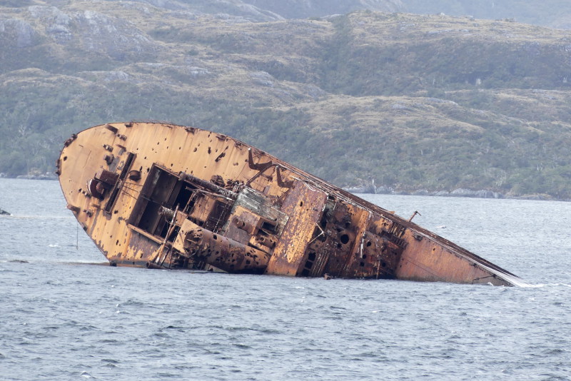
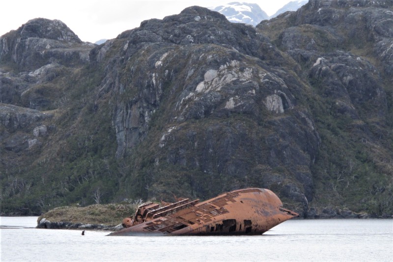
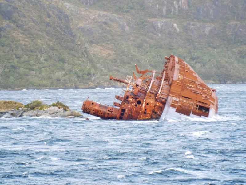
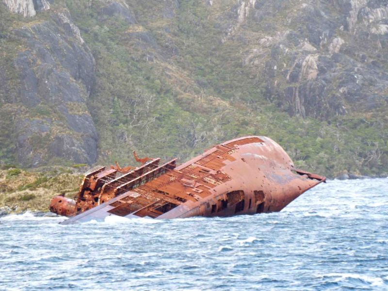
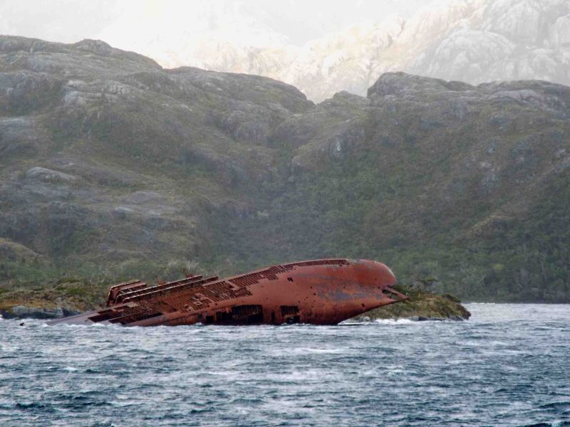
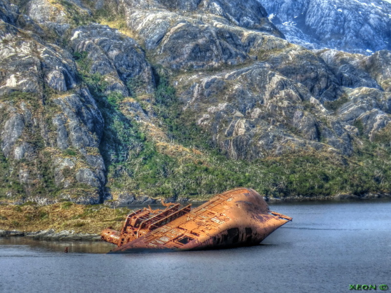
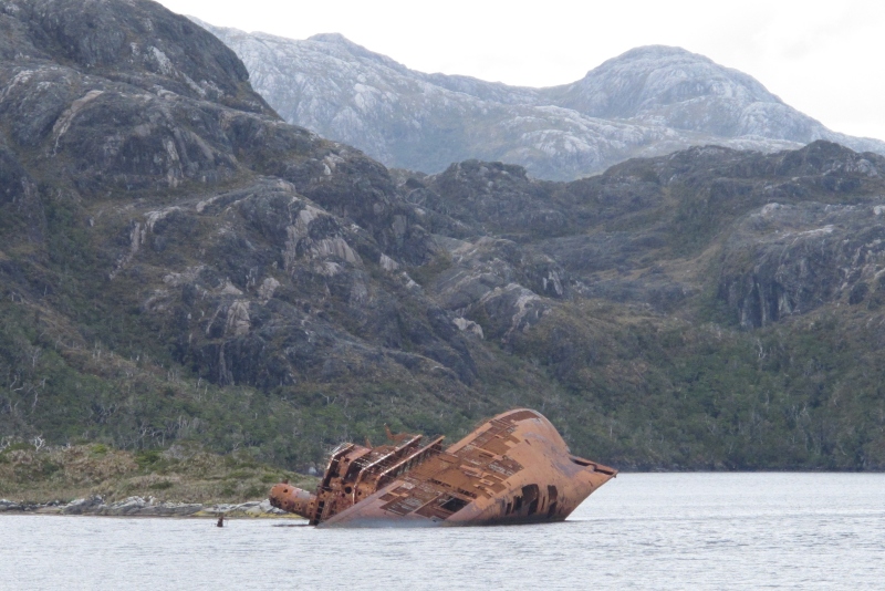
SANTA LEONOR - IMO 5242093

Photo
details
Description:
Isabel Island, Paso Shoal, Magellan Strait, Chile; March 22, 2014;
52º32.2' South, 073º36.83' West
ex USS Riverside (APA-102) Bayfield-class Attack transport;
built 1944 by Ingalls Shipbuilding Corp. Pascagoula; Yard no. 870;
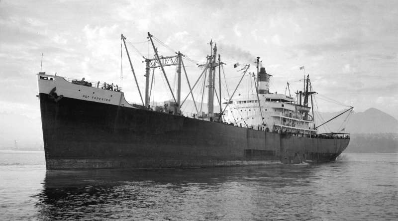
ex P & T Forester; ex Mormacwave;
L x B x D: 150.11 x 21.18 x 8.08 m;
stranded March 31, 1968/still there partially submerged;
see: http://en.wikipedia.org/wiki/USS_Riverside_(APA-102)
for a historic photograph of P & T Forester see:
www.shipspotting.com/gallery/photo.php?lid=1985020
The 6-digit LR (pre 7-digit IMO) number for Santa Leonor/P & T Forester: 524209
SS Santa Leonor (or according some sources Santa Leonora)
ran onto the rocks there apparently due confusing communication
between pilot's "alright" and helmsman's interpretation of "full right."
Consequently the vessel headed full speed to the shallow rocks.
All aboard were rescued.
Vessel
particulars
AIS Position
of this ship
There is no AIS Position Data available for this ship!
Would you like to add AIS Coverage?
 Add AIS Coverage
Photo
Categories
This ship exists in the following categories:
Wrecks & Relics - 11 photos
General cargo ships built 1940-1949 (Over 3000gt) - 1 photos
Photographers
of this ship
(7)
1 photos
2 photos
1 photos
2 photos
1 photos
1 photos
4 photos

COMMENT THIS PHOTO(11)
Edit
comment
Position on both the Chilean paper chart and Google Earth - where you can actually see her- is 52º32.2' South, 073º36.83' West. The neat round holes in her superstructure are due to Armada de Chile using her as a target. At low water you can see most of her foremast.
Paso Shoal has claimed quite a few ships over the years. At low water you can still see some remains of Hazel Branch wrecked in 1904. HMS Brazen ran aground nearby in September 1994 but was refloated.
Hola Mafiosa, está cerca de la costa de la más meridional de cuatro pequeños islotes cercanos al oeste de Isla Simpson que se pueden ver en el fondo de todas las fotos 'en el sitio'. La posición tanto en el gráfico de papel chileno como en Google Earth, donde realmente se puede ver, es 52º32.2' Sur, 073º36.83' Oeste. Los limpios agujeros redondos en su superestructura se deben a que la Armada de Chile la usó como objetivo. En aguas bajas se puede ver la mayor parte de su mástil delantero. Paso Shoal ha reclamado bastantes barcos a lo largo de los años. En aguas bajas todavía se pueden ver algunos restos de Hazel Branch naufragados en 1904. El HMS Brazen encalló cerca en septiembre de 1994, pero fue reflotado.
Edit
comment
Muchas gracias por la data,, otros daban ubicaciones que no eran y uno me llevo a un volcán y ahora con tus datos preciso, buscando todo se encuentra y mira esto:
https://satellites.pro/mapa_de_Chile#-52.536603,-73.612926,18
Copien y peguen todo el link de arriba... así van a ver el barco!!!
Ahí apareció el barco... siiiiiii!!!!
MUCHAS GRACIAS AMIGO @CISCO .... Saludos!!!!
ADMIN: Porque cada vez que pego un link sale cortado por decir esto:
https://satellites.pro/mapa_de_Chile#-52.536603,-73.612926,18
Si uno hace clic ahí lo manda a otro lado, y por eso tengo que estar diciendo COPIEN Y PEGUEN EL LINK!!!
Y asi me ha pasado en varios comentarios y en comentarios de otra personas, estaria bueno arreglar eso....PERDONE AMIGO Y SALUDOS ADMIN!!!
Edit
comment
Cheers,
dirk septer
Edit
comment
The rightmost digit is thus the sum of the check digit.
Example: IMO 9074729: (9x7)+(0x6)+(7x5)+(4x4)+(7x3)+(2x2)=139> the 9 at the end is the check digit!
Edit
comment
https://en.wikipedia.org/wiki/IMO_numbers
Edit
comment
but what do you exactly mean with:
"add right check digit to the end"?
Is it safe to assign IMO
And "Wrecksite" may not only be all that reliable,
they also posted four of my photos of this vessel
taken at this very remote location from Shipspotting
without the courtesy of giving me copyright credit.
Edit
comment
LR started allocating life-time 6-digit unique numbers to ships in the register in 1963, so for ships which didn't last long enough to get a 7-digit LR number (not sure when exactly they started), like SANTA LEONOR, a fake but usable "IMO" number can be constructed by adding the right check digit to the end. On that basis, provided 524209 is a genuine post-1963 LR number [that needs checking with a 1964-1968 copy of LR - I wouldn't take Wrecksite as being at all reliable on this), SANTA LEONOR would be, I think, 5242093.
Edit
comment
Edit
comment
Edit
comment
For more info:
http://www.wrecksite.eu/wreck.aspx?59767
Edit
comment