WELCOME TO SHIPSPOTTING.COM
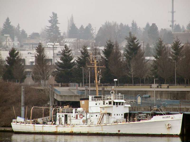
ALERT - IMO 7516931

Photo
details
Description:
Former US Coast Guard Active-class patrol vessel seen anchored off Jantzen Beach on the Columbia River. After being retired, she entered a life of various commercial activities that left her laid-up in the San Francisco area. Purchased by a group intending to restore her in 2005, she was moved to Portland, however her restoration progressed in small steps through 2011, and does not appear to have continued since.
USCG Doc #: 528251
Owner: Cutter ALERT Preservation Team Inc, Portland, OR
Flag: USA
Hailing Port: Portland, OR
Call Sign: WZU9399
Length: 38.10 m
Beam: 7.16 m
Draught: 2.29 m
Tonnage: 198 GT/135 NT
Year of Build: 1927
Builder: American Brown Boveri Electric Co, Camden, NJ
Yard Number: 322
Former Name:
USCGC ALERT WMEC-127 (1966-68)
USCGC ALERT WSC-127 (1927-66)
Vessel
particulars
Former name(s):
- Alert Wemc 127 (Until 1969 Oct)
AIS Position
of this ship
There is no AIS Position Data available for this ship!
Would you like to add AIS Coverage?
 Add AIS Coverage
Photo
Categories
Photographers
of this ship
(2)
1 photos
1 photos

COMMENT THIS PHOTO(1)
While moored on Hayden Island, the Alert and the Sakarissa were part of a growing homeless encampment, called the "Pirates of the Columbia", due to criminal activity along the coast.
The 2 boats were heavily damaged by graffiti and stripped of parts.
On the night of October 31, 2021, the Alert and the Sakarissa sank at their mooring on Hayden Island.
GOOGLE EARTH image year 2021:
https://i.ibb.co/FKLz1yY/Alert-2021.png
GOOGLE EARTH image year 2022:
https://i.ibb.co/W21DZLz/Alert-2022.png
LOCATION: 45°36'56.5"N 122°40'44.1"W
GOOGLE MAPS:
https://t.ly/WQbbZ
MORE INFORMATION:
https://en.wikipedia.org/wiki/USCGC_Alert_(WMEC-127)
https://thetidesofhistory.com/2022/01/23/the-loss-of-uscgc-alert-wsc-wmec-127/
https://www.navsource.org/archives/14/08269.htm
https://maritime-executive.com/article/uscg-to-remove-historic-derelict-vessels-in-oregon-s-columbia-river
http://columbiariverimages.com/Regions/Places/warships.html
TWO SUNK SHIPS!!! GREETINGS!!!
Edit
comment